Introduction
Almost all boundary disputes concern small parcels of land, often only inches wide, but despite the narrowness of the land a substantial difference to the enjoyment of the property may depend on who owns which side of the boundary.
The frustration of property owners can be easily understood when they turn to their Land Registry Title Plan expecting to see clear boundary positions & markings but do not. The General Boundary Rule, now embodied in statute (Land Registration Act 2002), prevents the Title Plan from showing precise boundaries (see later) and so one must look at all of the Title Documents, for each side of the boundary and fathom the clues therein contained in order to resolve the dispute. The purpose of this section is to demonstrate how to use the documents we provide in our Boundary Search to resolve any such dispute. If an alternative and more expensive method is used, e.g. employing a boundary surveyor) he will still obtain the documents we provide, as these documents are the starting point of alleviating any boundary dispute, and more often than not, the information therein contained, is sufficient.
Our Boundary Search includes all of the available documents for the properties on each side of the boundary, together with an informative guide (a smaller version of this book) and a further guide detailing Common Law Presumptions (as chapter 2 herein) that apply where there is no contrary agreement.
If it is still not possible to resolve the dispute then one of the more expensive options, discussed in chapter 4, may have to be used.
There are 3 ways of defining property boundaries:
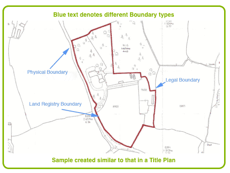
The Legal Boundary
This consists of a hypothetical line drawn between 2 properties in order to separate them. The line has no thickness and usually cannot be defined with any precision when looking at the Title documents or when examining the boundaries on the ground.
The Physical Boundary
Physical boundaries are identified on the ground and on maps and deeds by using physical features such as fences, walls, ditches, rivers, hedges, etc. Unlike a hypothetical line such features, in actuality, have thickness. In the case of fences, walls and hedges their thickness will change as they grow. Rivers may change their courses. It is preferred, but often not the case, that such boundaries be described as being either on one side of the physical feature, or as running along the centre.
The Land Registry Boundary
This is shown as red edging on the inside of the black line drawn by Ordnance Survey and shows the extent of the property ownership.
General Boundary Rule
Because of differences in the legal and physical property boundaries it became difficult to identify boundaries with precision and this lead to difficulties in completing registration of title, often causing disputes where disputes did not before exist, as registration required serving notices on all adjoining land owners and carrying out detailed surveys.
In 1925 the Land Registration Rules (Rule 278) introduced the General Boundary Rule, which is now adopted into the law by s60 Land Registration Act 2002, and is followed whenever a property is registered. This rule provides that the Title Plan shall be deemed to indicate the general boundaries only, and that the exact line of the boundaries shall be left undetermined. This rule is now governed by section 60 of the Land Registration Act 2002.
The application of the General Boundary Rule, however, is subject to plain and clearly described boundaries already contained within the deeds and documents of a property prior to first registration. The leading cases of Lee v Barrey 1957, Derbyshire County Council v Fallon 2007 and Strachey v Ramage 2008 all confirm this to be the case. These cases demonstrate the importance of looking at the pre-registration deeds and documents whenever there is an issue regarding property boundaries.
Section 60 Land Registration Act 2002
Boundaries
- (1) The boundary of a registered estate as shown for the purpose of the register is a general boundary. unless shown as determined under this section.
- (2) A general boundary does not determine the exact line of the boundary.
- (3) Rules may make provision enabling or requiring the exact line of the boundary of a registered estate to be determined and may, in particular, make provision about-
- (a) the circumstances in which the exact line of a boundary may or must be determined,
- (b) how the exact line of a boundary may be determined,
- (c) prodedure in relation to applications for determination, and
- (d) The recording of the fact of determination in the register or the index maintained under section 68.
- (4) Rules nder this section must provide for applications for determination to be made to the registrar.
Boundary Presumptions
England's common law provides that there are certain presumptions that can be made with regard to the physical boundary of a property, e.g. the famous "ditch and hedge" rule that provides that where land is bordered by a ditch and hedge the boundary is presumed to be the far side of the ditch from the hedge. This presumption is made following the pragmatic approach that a landowner, when making a ditch, would leave the spoil on his own land and plant his hedge upon it. Thus, both the ditch and the hedge would be located on his side of the boundary. Common law boundary presumptions, however, can be rebutted where there is evidence to the contrary. Usually any such evidence would be contained within the Title documents or old deeds, which illustrates the importance for examining all of the available documents.
The following chapter provides more detail about these common law boundary presumptions.
Two Sides of a Boundary
The Title documents to every property are unique, even though they often contain similar property rights. It is imperative, therefore, that when there is a boundary dispute the documents for each property are examined. Where the dispute involves more than two ownerships then the documents for the other ownerships should also be examined.